INTERACTIVE COMPARISON
Old vs New World Map: Mercator and Equal Earth Compared
Mercator and Equal Earth are both rigorous projections. They answer different questions: Mercator protects local angles, while Equal Earth protects relative area.
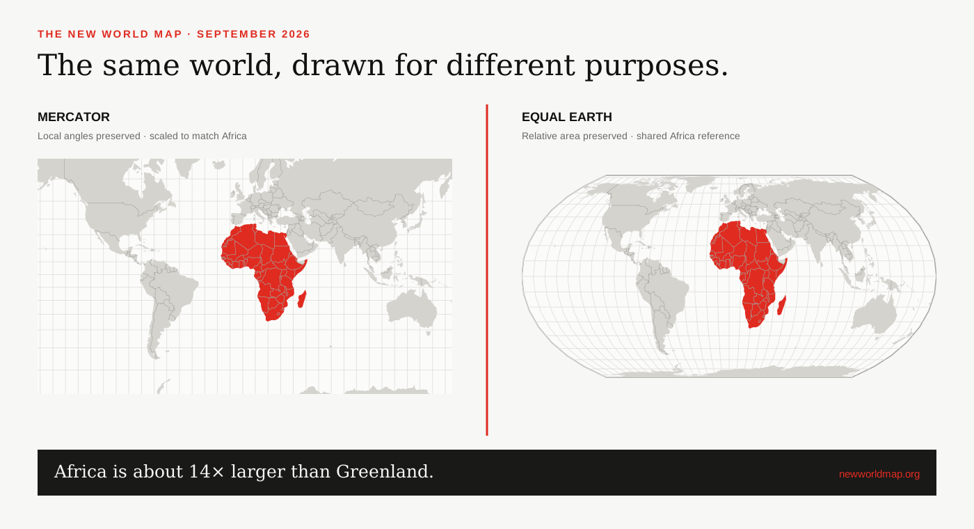
The shortest useful comparison
Mercator is conformal: at a sufficiently small scale around any point, angles and local shapes are preserved. That is valuable for navigation and contributes to its dominance in tiled web maps. But its scale rises toward the poles, so it is a poor canvas for comparing the areas of countries and continents.
Equal Earth is equal-area: mapped area stays proportional to geographic area. It provides a better visual basis for global statistics and continental scale, while accepting visible changes to local shape and direction.[1][3]
What the two maps preserve
Neither projection is ‘accurate’ in every sense. Accuracy has to name a property. Mercator preserves local angles but not area or global distance. Equal Earth preserves area but not local angles, every distance or every coastline shape.
For a choropleth map—where colour represents a rate or density—unequal area can also change a reader’s overall impression of the data. UN and International Cartographic Association guidance recommends equal-area or appropriate compromise projections for world SDG maps rather than Web Mercator.[2]
How the interactive comparison stays fair
Both panels use the same Natural Earth boundary geometry and the same drawing dimensions. Panning and zooming share one longitude–latitude centre and zoom factor. That prevents one map from being quietly framed more tightly than the other.
The footprint values are projection-dependent screen measurements. The boundary-derived geodesic area is calculated separately on the sphere. An official statistical area, when available, is shown as another labelled reference rather than blended into the geometry estimate.
Which one should you use?
For a nautical bearing, a conventional street-map interface or a task that depends on local angles, Mercator can be the right choice. For a classroom wall map, a global climate graphic, an election bloc or a visual comparison of Africa and Greenland, Equal Earth is usually the clearer choice.
The 2026 UN resolution follows that purpose-led view. It encourages equal-area mapping when relative continental size matters; it does not erase the technical reasons other projections exist.[5][6]
SOURCES & REVIEW
Sources for this article
We link to primary institutional material where possible and keep projection-dependent screen area separate from official statistics and boundary-derived geodesic estimates.
- UN Statistics / UNGEGN guidance on choosing map projections ↗
- Mapping for a Sustainable World — United Nations and International Cartographic Association ↗
- Šavrič, Patterson and Jenny, The Equal Earth map projection (2018) ↗
- Natural Earth 1:50m cultural vectors ↗
- UN General Assembly draft resolution A/80/L.104 ↗
- UN General Assembly, 80th session, 114th plenary meeting ↗
Published 2026-09-08 · Last reviewed 2026-09-15. News and institutional claims were checked against the cited record on the review date.
Read our method and editorial standards →