CURRENT EXPLAINER
New World Map 2026: What the UN Vote Actually Changed
On September 4, 2026, the UN General Assembly backed an Africa-led call for world maps that show continents in fairer relative proportion. It was a landmark vote about representation—not a change to borders, geography, or the needs of navigation.
What happened at the United Nations
The General Assembly adopted the ‘Correct the Map’ resolution by 164 votes to one, with six abstentions. Togo introduced the text on behalf of the African Group after the African Union had made fairer cartographic representation a continental priority. The vote placed a familiar classroom image—the rectangular Mercator world map—inside a much larger discussion about education, perception and whose scale is treated as normal.[2][5]
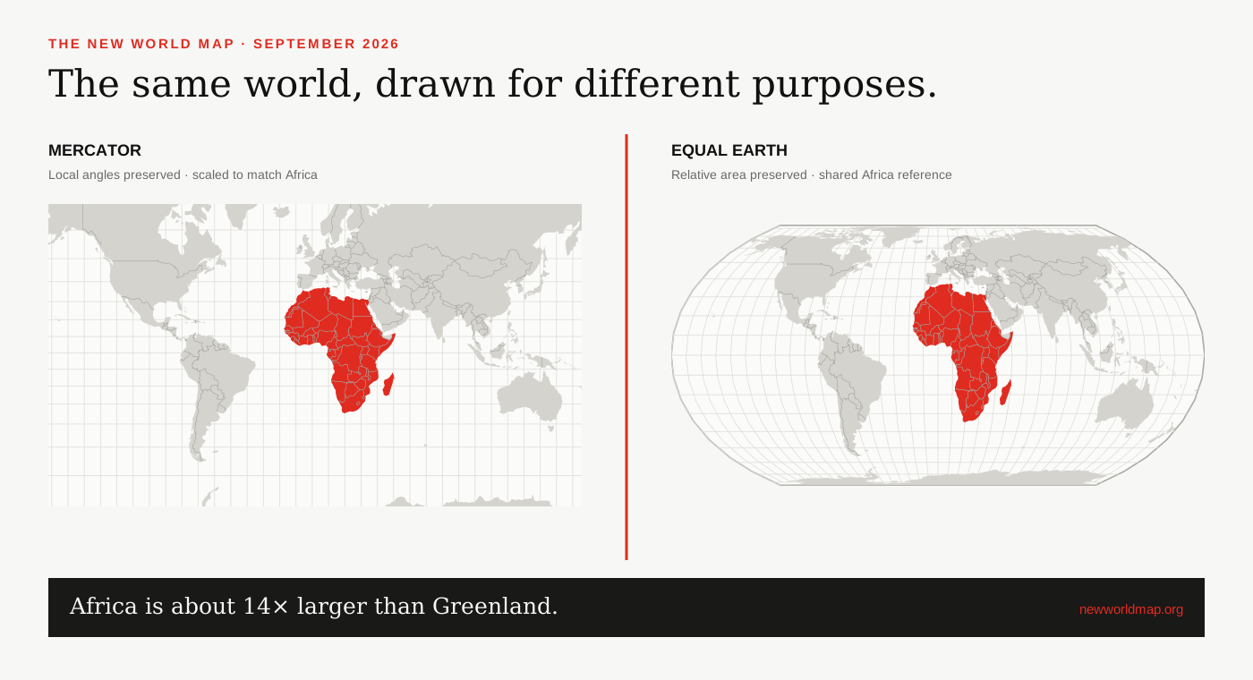
The resolution is a recommendation, not a global ban. It encourages governments, international organizations, schools, publishers, newsrooms and digital platforms to use Equal Earth or another equal-area projection when the purpose of a map is to compare the size of regions. Mercator still has legitimate uses, especially where its angle-preserving geometry serves navigation or interactive local mapping.[1][5]
Why Africa brought the issue forward
Africa spans about 30.37 million square kilometres. Yet on a Mercator world map, places far from the equator expand so dramatically that Greenland can appear comparable in size. Greenland is about 2.17 million square kilometres; Africa is roughly fourteen times larger. Equal Earth does not enlarge Africa. It stops the map from giving high-latitude land an outsized visual footprint.[0][7]
In February 2026, the African Union adopted Equal Earth and urged member states to revise national curricula. The AU framed the decision as a matter of cognitive justice: repeated images can influence how people imagine economic, political and geographic importance. That is a cultural argument built on a measurable cartographic fact—Mercator’s scale rises with latitude.[4]
What the vote did not change
No country became larger or smaller. No border moved. The resolution did not choose the names, boundaries, colours or political status shown on a particular map. A projection is the mathematical framework used to flatten coordinates from a globe; boundary data and political labels are separate editorial choices.[2]
It is also misleading to say the UN had always required Mercator and has now replaced it. The UN Secretariat says it has no single prescribed projection; its world maps have commonly used Robinson, Winkel Tripel and Eckert IV, while operational maps use projections suited to the region and task. The 2026 vote is best understood as a strong international recommendation to make equal-area views more common.[6]
How to read the map on this site
Use the linked comparison to keep the same country, geographic centre and zoom level visible in Mercator and Equal Earth. The red footprint measurement reports how much screen space the selected boundary occupies in each projection. The separate geodesic estimate reports the area enclosed by that boundary on a spherical Earth. Those are related observations, but they are not the same measurement.
The most useful question is not ‘Which map is true?’ A globe is the closest familiar model of the planet, while every flat map makes a trade-off. Ask instead what the map is for. For comparing the geographic weight of continents, an equal-area projection answers the question more honestly.
SOURCES & REVIEW
Sources for this article
We link to primary institutional material where possible and keep projection-dependent screen area separate from official statistics and boundary-derived geodesic estimates.
- UN General Assembly draft resolution A/80/L.104 ↗
- UN General Assembly, 80th session, 114th plenary meeting ↗
- African Union statement on the adoption of the Correct the Map resolution ↗
- African Union Assembly Decision 959 (XXXIX), February 2026 ↗
- Associated Press report on the UN General Assembly vote ↗
- United Nations Geospatial — map projection FAQ ↗
- United Nations Statistics — surface area data ↗
Published 2026-09-08 · Last reviewed 2026-09-15. News and institutional claims were checked against the cited record on the review date.
Read our method and editorial standards →