FIELD GUIDE
World Map Projections: A Practical Guide
There is no single flat map of the world without distortion. A useful projection is one whose distortions match the question the map is meant to answer.
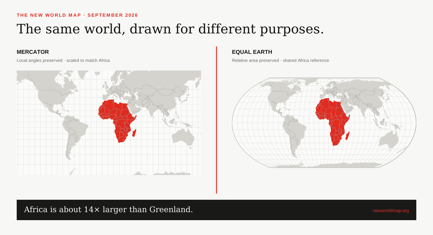
Why every flat world map distorts
A globe has a curved surface. A sheet of paper or browser window does not. Flattening the globe inevitably changes area, shape, distance or direction. The familiar rectangular outline of a map is itself a design choice, not a neutral container.
Distortion is not automatically an error. It becomes misleading when the map’s visual promise does not match its use—for example, asking readers to compare continental size on a projection that greatly inflates high latitudes.[1]
Four useful projection strategies
Conformal projections such as Mercator preserve local angles. Equal-area projections such as Equal Earth, Mollweide and Eckert IV preserve relative area. Equidistant projections keep distance accurate only from selected points or along selected lines. Compromise projections such as Robinson and Winkel Tripel spread several kinds of distortion without eliminating one globally.
The shape of the projection—cylindrical, conic, azimuthal or pseudocylindrical—describes another part of its construction. A regional map may perform better with a projection centred on that region than with any general-purpose world projection.[1]
Mercator, Robinson, Winkel Tripel and Equal Earth
Mercator offers straight constant-bearing lines and conformality but extreme polar area distortion. Robinson produces a balanced, rounded world without strictly preserving area. Winkel Tripel minimizes a combination of area, direction and distance distortion. Equal Earth pairs a similarly approachable outline with exact relative-area preservation.
The UN Secretariat does not prescribe one projection for every map. Its published guidance notes the use of Robinson, Winkel Tripel and Eckert IV for world maps, with regional and operational maps projected according to purpose. That is why the 2026 debate is better framed as changing defaults, not abolishing choice.[3][2]
A simple projection checklist
First, write down what readers must compare: area, direction, distance, local shape or an overall geographic pattern. Second, locate the region of interest and ask where distortion will concentrate. Third, label the projection and its limitation when a reader could otherwise mistake the image for a literal scale model.
For global area comparisons, start with Equal Earth or another equal-area projection. For a single country, use a recognised national or regional coordinate system. For navigation or familiar web tiles, Mercator may remain appropriate. If no flat projection answers the question clearly, use a globe or multiple coordinated views.
SOURCES & REVIEW
Sources for this article
We link to primary institutional material where possible and keep projection-dependent screen area separate from official statistics and boundary-derived geodesic estimates.
- UN Statistics / UNGEGN guidance on choosing map projections ↗
- Mapping for a Sustainable World — United Nations and International Cartographic Association ↗
- United Nations Geospatial — map projection FAQ ↗
- Šavrič, Patterson and Jenny, The Equal Earth map projection (2018) ↗
- Equal Earth projection project and technical overview ↗
Published 2026-09-08 · Last reviewed 2026-09-15. News and institutional claims were checked against the cited record on the review date.
Read our method and editorial standards →